In today’s digital and logistics-driven world, postal PIN codes are more than just geographical identifiers. They are the foundation of how parcels, letters, and even digital services are routed and delivered. Understanding the distance between two PIN codes can unlock efficiencies in business logistics, delivery operations, compliance with government norms, and much more. In India, where the postal system is vast and complex, calculating the distance between two PIN codes isn’t just helpful – it’s essential.
This blog explores what it means to calculate the distance between two Indian PIN codes, the methods involved, the industries that rely on it, and why a tool like the one at pincodetopincodedistance.com is becoming increasingly important for businesses and individuals alike.
1. What Is a PIN Code?
A Postal Index Number (PIN) code is a six-digit number used by India Post to identify specific geographic regions. Introduced on 15 August 1972, PIN codes help avoid confusion caused by similar place names and ensure systematic mail sorting and delivery.
Each digit in the PIN code represents a zone, sub-zone, district, and post office. For example:
- The first digit represents the zone (there are 9 zones in India).
- The second digit represents the sub-zone.
- The third digit represents the sorting district.
- The last three digits indicate the individual post office.
With over 1.5 lakh PIN codes in use, India has one of the most extensive postal systems in the world.
2. What Is the Distance Between Two PIN Codes?
The distance between two PIN codes refers to the straight-line (aerial) distance between the geographical centers (or post offices) associated with those PIN codes. It is not necessarily the road or travel distance, but the shortest path between the two points on the Earth’s surface.
There are two main types of distances:
- Straight-line distance: Also known as ‘as-the-crow-flies’ distance. Useful for quick estimates, zone classification, and tax-related calculations.
- Driving/Route distance: The actual travelable distance by road, which can be longer depending on infrastructure and connectivity.
Tools like pincodetopincodedistance.com offer straight-line distances instantly between any two valid Indian PINs.
3. How Is It Calculated?
The calculation typically involves:
- Mapping each PIN code to a geographic coordinate (latitude and longitude).
- Using the Haversine formula or Vincenty’s formula to calculate the shortest distance between the two points.
The formula considers the Earth’s curvature, making it more accurate than simple Pythagorean methods. Modern APIs and tools automate this calculation in milliseconds.
4. Why Does It Matter?
Knowing the distance between two PIN codes matters in several domains:
a. Logistics & Courier Services
- Helps in estimating delivery time.
- Optimizes route planning.
- Assigns deliveries to the nearest hub or warehouse.
b. E-Way Bill Generation (GST Compliance)
- The Indian government mandates e-way bills for transporting goods over a certain distance.
- The validity of an e-way bill is based on the distance between source and destination PIN codes.
- Incorrect distance can lead to penalties, delays, or rejection.
c. E-commerce & Last-Mile Delivery
- Platforms like Amazon, Flipkart use distance logic to decide:
- Which warehouse will fulfill the order
- Estimated delivery dates
- COD availability
d. Transportation and Fleet Management
- Distance impacts fuel cost, man-hours, and efficiency.
- Helps calculate delivery costs and pricing models.
e. Business Analytics & Decision Making
- Retail businesses analyze customer proximity.
- Real estate portals showcase distances to urban hubs.
- Insurance companies assess claim risk based on service center proximity.
5. Use Cases of PIN Code Distance Tool
1. SMEs and Transporters
They use tools to generate e-way bills quickly, calculate the distance, and print reports for compliance.
2. E-commerce Sellers
Independent sellers on marketplaces use the tool to forecast shipping costs and estimate delivery time.
3. Service Aggregators
Apps like Swiggy Genie, Porter, and Dunzo can use such data to provide real-time cost and time estimates.
4. Field Workforce Allocation
Firms offering installation or service visits (AC repair, solar installation) plan their manpower deployment using PIN code distance.
5. Bulk Calculation for Enterprises
Large businesses may want to upload CSV files of PINs to calculate thousands of distances at once. This feature is under development at pincodetopincodedistance.com.
6. Difference Between PIN Distance and Google Maps Distance
| Feature | PIN Code Distance Tool | Google Maps |
|---|---|---|
| Type of Distance | Aerial (Straight-line) | Driving/Walking |
| Ideal for | Logistics, GST, Bulk Reports | Navigation, Real-time routing |
| Speed | Very Fast | Slightly Slower |
| Accuracy | High (for straight-line) | High (for road routes) |
| Use-case | Legal compliance, Analytics | Physical travel, Delivery |
Using a specialized PIN-to-PIN distance calculator gives quicker and more relevant results in specific use cases like GST e-way bills and logistics planning.
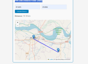
7. How to Use the PIN Code Distance Tool
Using pincodetopincodedistance.com is easy:
- Go to the homepage.
- Enter the From PIN Code and To PIN Code.
- Click on Calculate Distance.
- Instantly view the aerial distance in kilometers.
Pro Tip: Bookmark the page or install as a shortcut on your phone to access it quickly while on the go.
8. Future Enhancements to Look For
The tool is evolving rapidly and may soon include:
- CSV upload for bulk PIN-to-PIN distances.
- Driving distance estimates via integration with Maps APIs.
- Mobile app version.
- Multi-language support (Hindi & regional languages).
- API Access for developers and business integration.
These additions will make it even more powerful for daily business operations.
Conclusion
Understanding the distance between two PIN codes is no longer just useful – it’s strategic. From e-commerce to compliance, and from route planning to delivery costs, it’s a number that affects revenue, efficiency, and legal correctness.
Tools like pincodetopincodedistance.com are simplifying this task for everyone, from small business owners to logistics giants. Whether you’re generating e-way bills, calculating delivery costs, or optimizing your service areas – this tool can be a powerful addition to your digital toolkit.
Ready to simplify your logistics? Try the Free PIN Code Distance Calculator now and make smarter business decisions!